About Me

My photo
I am a lifelong student of military history with particular interest in the Battle of Antietam. I work for the federal government in Washington DC and have two young adult children who I love very much. I currently volunteer at Antietam and devote much time to the study of this battle and the Maryland Campaign. I enjoy collecting notable contemporary quotations by and about the men of Antietam. Since 2013 I have been conducting in depth research on the regular artillery companies of the Union Army and their leaders. I hope to turn this into a book on this subject in the future. My perspective comes from a 28-year career in the U.S. Army. Travels took me to World War II battlefields in Europe and the Pacific where American valor ended the tyranny of Nazism and Empire. But our country faced its own greatest challenge 80 years earlier during the Civil War. And it was the critical late summer of 1862, when Robert E. Lee launched the Maryland Campaign. It is an incredible story of drama, carnage, bravery, and missed opportunities that culminated around the fields and woodlots of peaceful Sharpsburg MD. So join me as I make this journey South from the North Woods.

Tuesday, March 31, 2009

Visit the New Antietam Blog - Walking the West Woods

My good friend and fellow Antietam volunteer Jim Buchanan recently created a new blog titled Walking the West Woods. Jim possesses a wealth of information on this area of the battlefield and I look forward to his insightful posts. His scholarly approach and careful analysis will help everyone interested in the Battle of Antietam increase their understanding and appreciation of this important part of the battlefield. So look for Jim anytime at his blog or if you are lucky, see him in person in the West Woods (stop 5 of the driving tour) when you visit the park on Saturdays or Sundays.
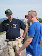
The photo to the left was taken on the recent Nicodemus Heights hike on March 22. The view is from Hauser's Ridge looking east. You can see the Philadelphia Brigade Monument surrounded by the trees of the West Woods. If you interest is aroused, visit the park this Sunday, April 5th, and take the Ranger-led hike of the West Woods. This only happens once a year in the spring when it is cool and the vegetation is sparse thereby improving the views. The West Woods hike begins at the New York Monument at 1:15 PM.

Sunday, March 22, 2009

Nicodemus Heights Hike

A beautiful spring day brought out over 50 hikers to the long anticipated hike to Nicodemus Heights. An important part of the Battle of Antietam, Nicodemus Heights is on private property and special arrangements must be made with the landowner for visitors to come on the ground. This hike hasn't been offered to the public for two years so there was a lot of interest. Ranger Brian Baracz who led the hike and makes the arrangements with the landowner said this was one of the largest groups of hikers that he has had. Under clear sunny skies, and with Brian, an acknowledged expert on the terrain to take us around, we were not disappointed.

We started in the North Woods and headed west toward the Nicodemus Farm across Route 65. From the Nicodemus Farm, we scaled the Heights where the view is spectacular. Most of the photos in the slide show were taken from that vantage point. The one at the top of this blog looks northeast back at the Joseph Poffenberger Farm. From Nicodemus Heights, we hiked south to Hauser's Ridge and from there, we headed east and crossed Highway 65 at Starke Avenue. The final part of the hike took us through The Cornfield back to the North Woods.

There is a great essay about the fighting on Nicodemus Heights in The Antietam Campaign edited by Gary Gallagher. The essay titled "Defending Lee's Flank - J.E.B. Stuart, John Pelham, and Confederate Artillery on Nicodemus Heights" is by Robert E. L. Krick.

We are well into the spring hiking season at Antietam. This is a great time of year to visit the battlefield. There is little foliage and the views are grand. It is also cool and comfortable for hiking. Hikes run about 2 hours and 15 minutes. For a link to all the scheduled programs, start times and locations, at Antietam National Battlefield this year, click here. See you on the trail.

When using the slide show, click on the photos. You will then see a Google map showing the location where I shot each photo and you can watch the photos at your own speed.

Sunday, March 15, 2009

East Woods Reforestation Begins


Yesterday marked the official start day of an ambitious project to reforest the open ground at Antietam National Battlefield that was originally part of the East Woods. I was proud that my son Jim Rosebrock elected as his Boy Scout Eagle project, to plant trees in the East Woods. He with several other groups are the first ones to plant trees on the grounds south of the current East Woods. Jim, age 17, brought eighteen boys and parents from Boy Scout Troop 279 in Point of Rocks Maryland. Antietam Ranger Joe Calzarette taught the boys how to properly plant the trees and for the next few hours, the work went forward. In time I am told, there will be some 11,000 trees planted. We made a good start putting around 120 trees into the ground yesterday. Afterward, the folks from Troop 279 got to watch Antietam's volunteer artillery battery, Battery B, 4th US Artillery firing their Model 1857 Napolean behind the Mumma Farm House as the boys consumed a mountain of pizzas. It was a great day!

The Western Maryland Interpretive Association (WMIA) is accepting donations for this effort in the Museum Bookstore at the Visitor's Center. If you want to get physical and actually plant some trees, you can schedule this by contacting Joe at his email: Joe_Calzarette@nps.gov.

Friday, March 13, 2009

With the First Corps to Frosttown Gap - September 14, 1862


This slideshow traces part of the path of the Union First Corps as they left Middletown Maryland and approached and fought their way into South Mountain around Frostown. These photos were shot on March 7, 2009. As always, you can slow down the action by double clicking the photos and also see a location where I shot the photo in Google Maps. There has been some discussion lately on the Talk Antietam Yahoo Group on the road network around Turner's Gap. While this may not shed a lot of light on the road network and all the gaps, you get some idea of the nature of this difficult terrain and the challenges faced both by the Union commanders Meade and Hatch and their Confederate counterpart Robert Rodes.